
This is the fourth time I have walked the West Highland Way. I find the information given by EasyWays is first class.
– Moira
Route Stops
Arrive in Inverness the vibrant “Capital of the Highlands”
The official start point of the John O’ Groats Trail begins at Inverness Castle overlooking the River Ness in the centre of Inverness. The trail follows the river out of the Highland Capital before crossing the Kessock Bridge high above the Beauly Firth by pedestrian walkway before edging around Ord Hill on the Black Isle. Munlochy Bay then appears following on to the village of Munlochy and heading north through open farmland to Culbokie.
Time 6 – 7 hours
Ascent 467m
Depart Culbokie on quiet roads before joining the A9 Causeway across the Cromarty Firth.with spectacular views either side Please note that this is a very busy crossing and care must be taken at all times. On the northern side of the first the trail returns to It then leaves the busy road verge and soon joins a minor road through the village of Evanton that follows the Main A9 to Alness.
Time 3.5 – 4.5 hours
Ascent 92m
The 3rd Stage of the John O’ Groats Trail continues north east on minor roads from Alness through the open Easter Ross landscapes and Forestry Commission Plantations before a final descent into the quant of Tain home of the iconic Glenmorangie Distillery.
Time 5 – 6 hours
Ascent 290m
Today the trail crosses the Dornoch Firth, once again by a causeway leaving Easter Ross behind and entering the county of Sutherland. Before crossing find time to visit the Glenmorangie Distillery which is located on the south side of the firth.
This stage is offers varied walking with some walking alongside the Main A9 road before reaching a mix of paths, minor roads, and woodland. This is a particularly beautiful part of the route where it is possible to see large offshore oil exploration platforms moored in the deep water of the firth.
Time 4 – 4.5 hours
Ascent 51m
The fifth stage of the trail involves mainly coastal walking departing Dornoch to head north past The Royal Dornoch Golf Course and the seaside holiday village at Embo. Thereafter the route encircles Loch Fleet crossing by way of the A9 and the Mound Rock to leave the road and return through Balblair Wood to reach shoreline pathways beside the town golf course into Golspie.
Time 6.5 – 7 hours
Ascent 127m
Depart Golspie by the Main A9 road to the north edge of the town where the trail heads off towards the coastline by way of a small bridge over Golspie Burn. Heading north the route then passes the magnificent Dunrobin Castle following the shore all the way until reaching the lovely town of Brora.
The route to Brora marks the 6th Stage of the JOG Trail (6.25 miles / 10 km)
Depart Brora on a route between the local golf course and the pristine shoreline sands, crossing Loth Burn (where care must be taken in crossing), before continuing between the coast and the railway and eventually climbing to Portgower where it crosses the A9 once again and the rail line before descending through farmland on minor roads into Helmsdale.
Time 8.5 – 10 hours
Ascent 259m
If you wish to split this day, with an additional overnight in Brora, please make note of this in the enquiry form.
The intial stage of today’s walk to Berradale is the most elevated section of the trail, crossing moorland high above the coastal cliffs offering views of the Ord of Caithness Headland. Two ravines then follow on track through moorland to cross a steep gorge with rushing Ousdale Burn before passing an ancient prehistoric broch and the ruins of Badbea Village where the local population were driven off their homes to relocate during the time of the Highland Clearances.
The route to Berridale marks the 8th Stage of the JOG Trail (9 miles / 14.5 km)
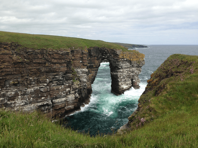
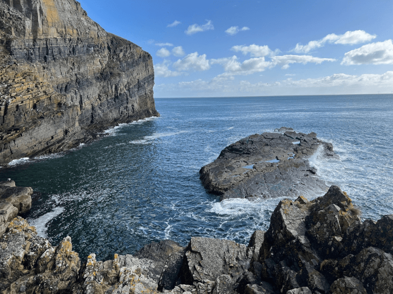
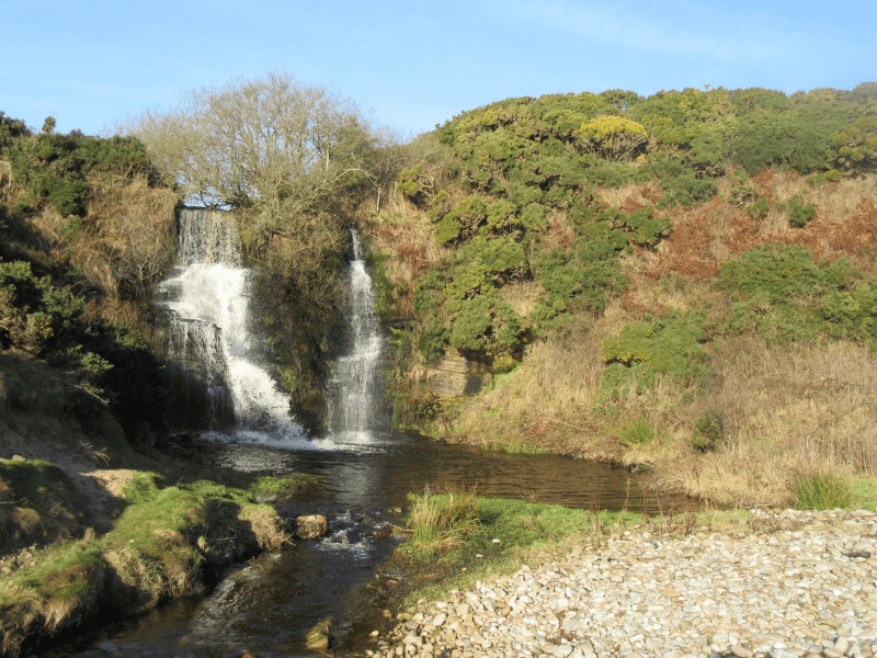
The route from Berridale to Dunbeath, starts at the swing bridge over the Berriedale Water and ascends to continues on cliff top trails offering wonderful views and several interesting landscape features along the way. There is a fine coastal arch, a waterfall falling into the sea and an impressive rock stack along the way.
Time 10 – 11.5 hours
Ascent 1,072m
If you wish to split this day, with an additional overnight in Berridale, please make note of this in the enquiry form.
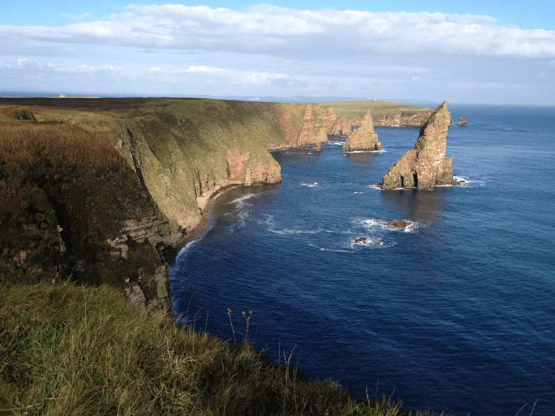
A dramatic coastal walk along cliff tops that links the harbours of Dunbeath, Latheronwheel and Lybster. Today encounter sea stacks, a natural arch and a ruined castle with the challenge of three ravines to cross and where landowners have retained some fences to cross. Terrain can be uncertain at times over uneven ground and therefore care must be taken at all times.
Time 5 – 6 hours
Ascent 549m
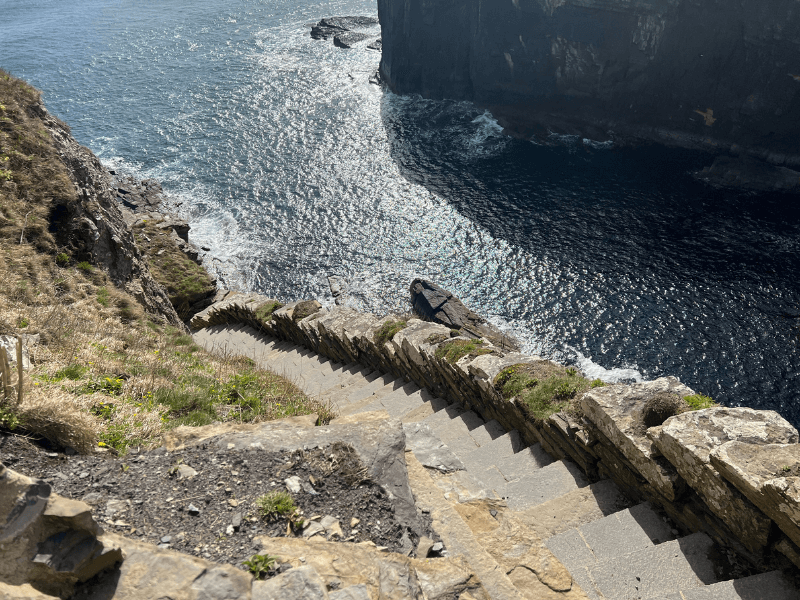
Wonderful scenery dominates this stage of the John O’ Groats Trail with sea stacks, waterfalls and a number if inland ravines. Pass the ancient secluded Clyth Harbour before reaching the famous Whaligoe Steps, the remains of ancient sea access steps at The Haven Harbour. Once again care must be taken on this section as there are many fences to cross and the terrain can be difficult at times.
Time 5 – 6 hours
Ascent 580m
Begin the 12th Stage of the trail today by departing the stunning Whaligoe Steps by the left of the stone building (a private residence) and follow the markers to the north. Continue along cliff tops, through scattered farms before passing a fascinating hole with a view straight down to the sea. Witness spectacular natural arches and sea stacks to arrive at the pretty harbour of Sarclet before reaching the ruins of Old Wick Castle to end in the town of Wick, the largest settlement on the John o’ Groats Trail.
Time 5 – 6 hours
Ascent 882m
The penultimate stage of the trail departs the town of Wick on clifftop walking past Wick Airport to continue north to Noss Head lighthouse, the dramatic ruins of Castle Girnigoe and the impressive Ackergill Tower (now a hotel) to reach the long set of sands at Sinclair’s Bay. This stage can be demanding in inclement weather and involves crossing the River of Wester that enters the sea at the mid-point of the sands and can be almost impassible at times and a detour inland to the A99 road is required to pass safely into Keiss.
Time 5 – 6 hours
Ascent 200m
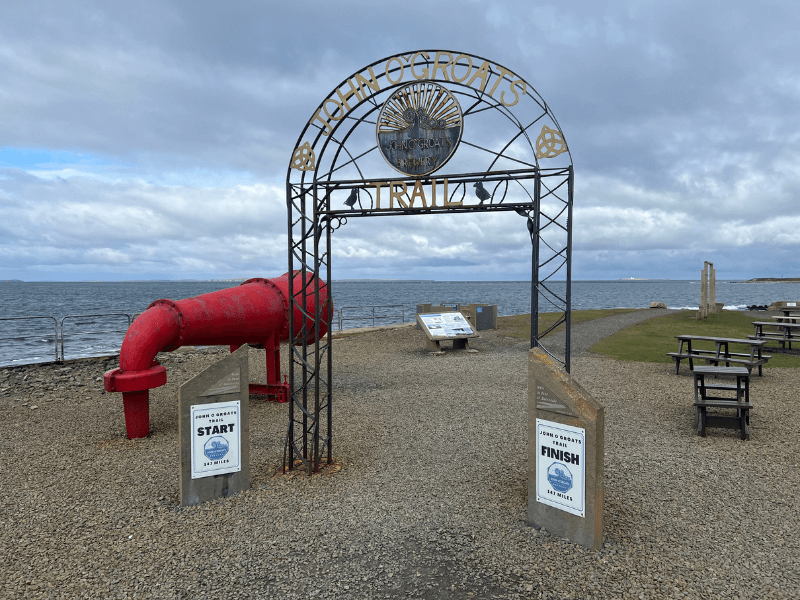
The final stage of the trail passes the impressive ruin of Keiss Castle and follows the coast passing Nybster Broch with wonderful clifftop scenery around Freswick Bay to reach Duncansby Sea Stacks and the Duncansby Lighthouse before arriving at John O’Groats and the end of the trail and the iconic signpost known all over the world.
Time 6 – 7 hours
Ascent 325m
Congratulations – you have completed The John O’Groat’s Trail! After breakfast, it is time to set off on your onward journey.
John O’Groat’s Trail
147 miles / 233 km
The John O’ Groats Trail offers an amazing walk experience of coastal route from Inverness, the Capital of the Highlands, to John O’ Groats in the far north of Scotland.
Walk on isolated shorelines, along cliff tops, around rolling farmland and through forest footpaths in an ever northerly direction, that is both exciting and educational in terms of local history and viewing the wildlife of the area.
This is one of the longest trails in Scotland, (50 miles longer than the West Highland Way) and therefore EasyWays is offering the route as separate Southern and Northern Sections over 7 or 8 overnights, with a variation of between 11 and 14 overnights for walkers who want to complete the route in full.
A carefully selected choice of local Inns, B&B’s and small hotels, offering the best in Scottish hospitality, awaits all who embark on this walk with the option of adding a Day Tour crossing to Orkney at the end point in John O’ Groats.
The Orkney Islands, with their rich history of neolithic ruins of Skara Bra and Ring of Brodgar combined with the WW2 locations such as the Churchill Barriers and Italian Chapel, make for an excellent optional extra to the JOG Trail.
South Stage 6 days / 7 overnights Inverness to Helmsdale (78.75 miles / 126.25 km)
North Stage 6 days / 7 overnights Helmsdale to John O’ Groats (66 miles / 106.75 km)
Full Trail 11-14 nights Inverness to John O’ Groats (145 miles / 233 km)
Ask for information of the Orkney Extension at time of booking enquiry.
Quality Accommodation
Door to Door Baggage Transfer (max 18kg)
Rucksack Readers Guide Book
Location Details For Each Accommodation
Travel Information from start to finish
Sugguested Equipment List
Route Packages
What’s included?
- 7 nights’ accommodation for 2 people sharing in quality en-suite B&Bs, guest houses, inns and hotels.
- Breakfast
- Door to door baggage transfer – maximum 18 kg per bag
- JOG Trail Guide Book
- GPS Mapping App detailing full tour and accommodations
- Travel information to the start and from the finish of the walk
- Suggested equipment list
- Emergency support
What’s not included?
- Evening meals, packed lunches and drinks
- Travel insurance
What’s included?
- 11 nights’ accommodation for 2 people sharing in quality en-suite B&Bs, guest houses, inns and hotels.
- Breakfast
- Door to door baggage transfer – maximum 18 kg per bag
- JOG Trail Guide Book
- GPS Mapping App detailing full tour and accommodations
- Travel information to the start and from the finish of the walk
- Suggested equipment list
- Emergency support
What’s not included?
- Evening meals, packed lunches and drinks
- Travel insurance
First established in 1996, EasyWays has built a strong reputation with the UK and International walking community in the delivery of walking tours throughout Scotland.
The template of every successful business is grounded in long term relationships, and EasyWays, along with our accommodation providers and baggage transfer companies work as one to ensure your walk experience is both enjoyable and memorable.
As a Scottish based company we are close at hand to the walking routes and pride ourselves in delivering a bespoke service – tell us what you would like and we will build an itinerary to match.


