


The EasyWays team took care of all the logistics, including booking comfortable accommodations and arranging baggage transfers between each stop. Every hotel and guesthouse I stayed at was welcoming, clean, and perfectly located along the route. It was such a relief to know my bags would be waiting for me at the end of each day—one less thing to worry about after a full day of hiking!
What really stood out was the attention to detail and personalised service. The comprehensive information pack provided before my journey was full of useful tips, detailed maps, and a clear itinerary that made navigation a breeze. Whenever I had a question, the team was quick to respond with friendly and helpful advice.
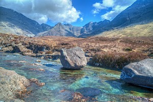
Walking the West Highland Way is a bucket-list adventure, and EasyWays made it all the more special by handling the planning so I could focus on the incredible scenery, from the dramatic peaks of Glencoe to the serene shores of Loch Lomond. This was my first walking holiday, and I’m already looking forward to booking my next trip with them.
If you’re looking for a hassle-free walking experience where everything is taken care of, I wholeheartedly recommend EasyWays. Their expertise and thoughtful planning made this one of the most memorable trips of my life!

From start to finish, everything ran so smoothly. The accommodations were lovely and we couldn't fault the selection EasyWays booked for us. We will definitely book with them again.

1. Payments are made in a way that you do not know exactly what you will get until after you pay, you get a general program and then refunds are not easyways. read the small letters!!
2. In case of no accommodation, they offer a transport with bus or taxi to a different location. in our case taxi was delayed for a very long time ended in very late arrival to the gust house.
3. In accurate place of the first luggage pickup


They arrange for your luggage to the shifted from accommodation to accommodation so all you need to do is focus in your walk. They arrange any necessary transfers. They take out all the stress of planning popular tours like the West Highland Way. However if your have special requirements they are able to tailor tours to suit your needs. They can help you arrange for dogs/young children to travel with you based on accommodation that can host these requirements. Either fill in an enquiry form via thier website or send the team an email. I am an amateur walker and Easyways showed me how much more I can do and inspired me to some phenomenal walks and see the best of Scotland.


We have been very happy with the standard of accommodation over the years.
The staff at Easyways are great to deal with - friendly and helpful and the whole process is entirely painless.
In a nutshell, we automatically turn to Easyways when considering a long walk - wouldn't go anywhere else!
Route Stops
The North Coast Trail begins at Thurso, the most northerly town on the British mainland. Located at the end of the A9, the main transport route through Scotland, Thurso is 300 miles from the main industrial area of Central Scotland and the cities of Glasgow and Edinburgh. It is also the birthplace of Sir William Alexander Smith (1854 – 1914), the founder of the Boys’ Brigade, who was born in Pennyland House, now a Guest House used by EasyWays on the walk
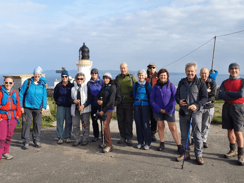
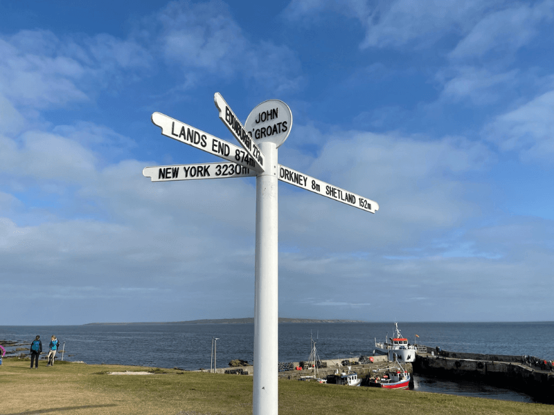
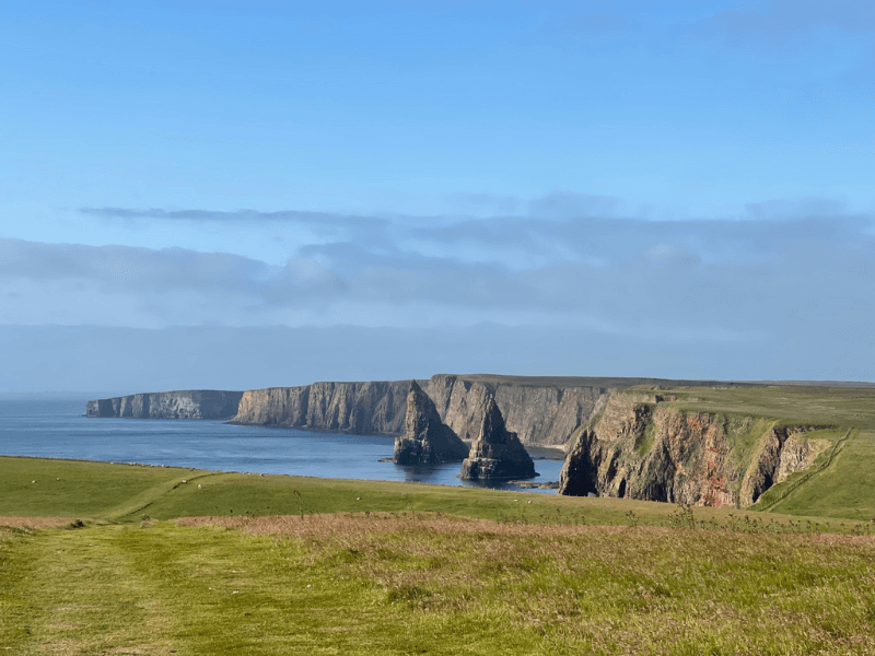
The morning begins with a private transfer to John O’ Groats for a walk around the local area to Duncansby Head Lighthouse and The Stacks, towering sea stacks believed to have stood in this position for the last 6000 years, slowly eroding away due to the raw power of the North Sea
This walk can be extended by taking the local bus to Freswick and walking north back to Duncansby Head for an extended view of the Stacks. Walk distance (5 miles / 8km). Check bus times on arrival into John O’ Groats as the timetable can be subject to late change.
Alternatively include a day on Orkney although this will mean an early departure from Thurso to connect with the 08.45 JOG Day Trip to the islands.
The ferry return time allows connection by public bus back to Thurso.
Please advise EasyWays at time of booking if you intend to take the Orkney Day Trip Option.
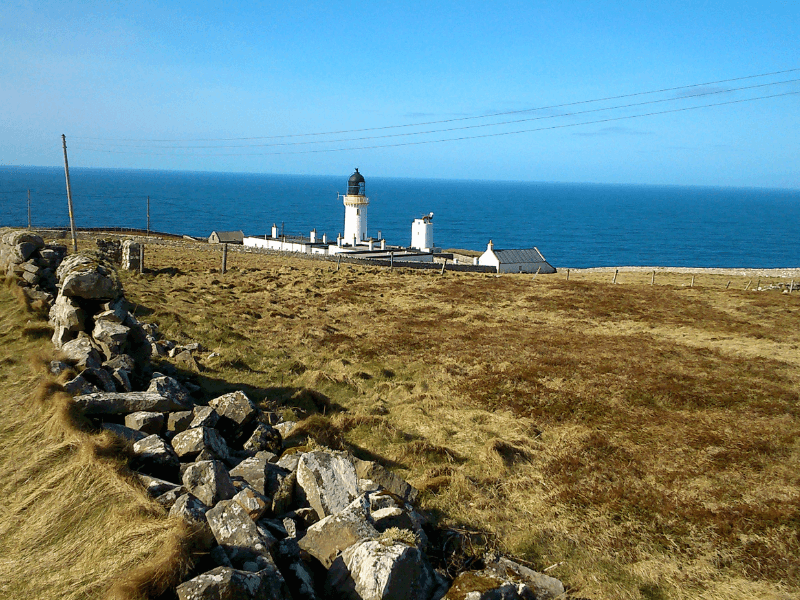
Today begins with another private transfer to Dunnet Head Lighthouse, the most northerly point on the British Mainland. Return by following the western side of the coastline on unmarked tracks overlooking spectacular cliffs with views to the Orkney Islands to the north.
Descend Dunnet Head past secluded Peedee Bay and down to Dwarwick Pier where the hard road should be taken behind the row of cottages all the way to the main A836 road. Here you will find Dunnet Bay (Gin) Distillery and the Northern Sands Hotel before reaching the eastern end of Dunnet Bay. Walk across the golden sands returning to the Castletown at the west side of the bay for the public bus return to Thurso.
Holborn Head and Scrabster (6.75 miles / 11 km) – morning walk before transfer
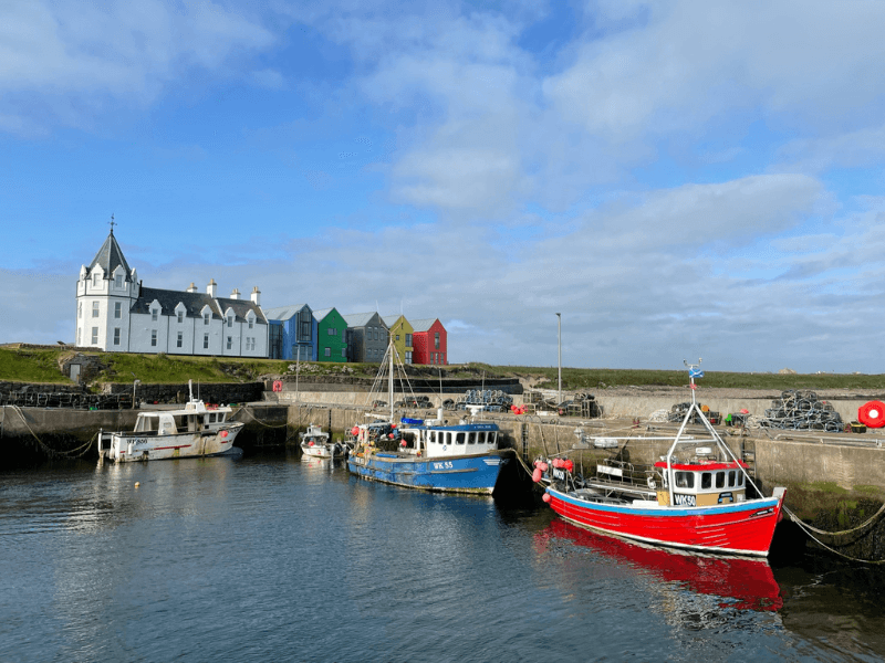
Begin the day with a morning visit to the picturesque harbour at Scrabster and onward walk out to Holborn Head before returning to Thurso for private transfer in the afternoon to Strathy.
Strathy Point (5 miles / 8 km) – afternoon or evening
On arrival at Strathy, take a late afternoon or early evening walk out to Strathy Point that projects sharply out from the central section of Scotland’s northern coastline. An undemanding but interesting walk over flat terrain with Strathy Lighthouse to mark the destination before returning on the same path. Some excellent coastal views including a dramatic arch, it is also a great place to watch for cetaceans, with whales and dolphins frequently seen in the summer months.
Ard Mòr Circuit (3 miles / 5 km) – morning
Morning transfer to Bettyhill with time before lunch to walk around Àrd Mòr, a high peninsula north of Bettyhill Village. The route offers an elevated walk over the rough and pathless landscape however it gives superb coastal views. Take the back road in Bettyhill, signed for the Pier, and then turn right off it onto a track – signed for Àrd Mòr viewpoint. Just beyond a lochan as the road bends left. A short distance along the track there is a large parking area off to the left side. Begin the walk here and follow the track which leads down to some picnic tables and a memorial overlooking Farr Bay.
Torrisdale Bay and Broch Invernaver (5 miles / 8 km)
In the afternoon take the A836 road west towards Tongue to cross the River Naver on the iron bridge to access Torrisdale Bay. Care should be taken here as the grass footpath does not extend the full distance and some road walking is required.
The walk takes in a spectacular beach, dunes, riverside and moorland, as well as visiting an iron-age broch with stunning views. It passes an area of Special Scientific Interest due to the rare plants and archaeological remains however the section over the top can be hard to follow so some navigation skills are needed.
Caisteal Bharraich, Tongue – (2 miles / 3.5 km) – morning
Take a morning transfer and, on arrival in Tongue, walk the short distance to Caisteal Bharraich, (Castle Varrich) a prominent ruined castle in a superb prominent position overlooking the Kyle of Tongue. A very pleasant short walk from Tongue village that allows the afternoon free for the more demanding walk around the Kyle of Tongue.
Kyle of Tongue Circuit – (12 miles / 19 km) – afternoon
A circular walk beginning and ending in the village of Tongue. Take the road south to pass Tongue Post Office towards Ribigill and on south passing two lochans to cross the Kinloch River and turning before Kinloch Lodge, the furthest away point on the route.
From here turn north to reach the top of the Kyle walking up the western side of the coastline until the causeway bridge is reached. Turn right to cross the Kyle and return to the route starting point in Tongue.
Ben Loyal – (13.75km / 8.5 miles) – option for more experienced walkers
Ben Loyal has a very distinctive profile, leading to it being known as the Queen of Scottish Mountains.
Access is by a quiet road south of Tongue taking the signpost for Ribigill on through a series of gates over boggy terrain to find the beginning of the gradient.
Rising in an isolated position above the north coast, it makes for a fantastic day out. The long ridge with four peaks offers superb 360 degree views of bog, moor, mountains and sea.
Kyle of Durness to Cape Wrath ( 3 miles / 4.8 km)
Local Cape Wrath / Kearvaig walking only
Today an early morning private transfer is arranged from Tongue, past Durness to the Keoldale ferry point on the Kyle of Durness for crossing and onward local minibus transfer to the Lighthouse at Cape Wrath, the most north-westerly point on the British mainland. Time spent at the lighthouse before walking to idyllic Kearvaig Beach (suggested lunch and swimming spot) before rendezvousing with the minibus for the return to Keoldale ferry.
The lighthouse at Cape Wrath was built in 1828 by Robert Stevenson and was manned until 1998 when it was converted to automatic operation. It is a Category A listed building, 20 metres tall, consisting of a white-washed tower built of granite with a single-storey semi-circular base building.
Cape Wrath has a wide diversity of wildlife, including red deer golden eagles and a variety of seabirds such as cormorant and gannet can be seen on this walk.
Keoldale – Durness (7 miles / 11.2 km)
On return to Keoldale the return to Durness is by the west side of the Durness Circuit to Balnakeil Craft Village, then on quiet roads through Durness and on to your hotel for the evening.
Smoo Cave and Durness (2 miles / 3.2 km)
A more relaxing day with local walking around Smoo Cave located on the eastern approaches to the settlement of Durness. We take time to view the cave from the beach before reaching Durness by way of Sango Sands on a mix of seaside tracks and road walking in time for lunch.
Smoo Cave and Bhlar Duibhe (4.5 miles / 7 km) – morning
Begin the day with a transfer to Smoo Cave located on the approaches to the settlement of Durness. Discover the cave and the local beach are before taking a circular walking route inland. Thereafter reach Durness by way of Sango Sands in time for lunch.
Balnakeil and Faraid Head (4.5 miles / 7 km) – afternoon
In the afternoon take time to discover Durness and Balnakeil Craft Village before walking the circular route out past the beaches at Balnakeil to Faraid Head. Overnight at Durness.
Kyle of Durness Circuit (5.6 miles / 9 km) – optional
In the event of inclement weather preventing a crossing to Cape Wrath it is possible to take a local walk around the Durness Circuit at the western end of the town adjacent to Balnakeil. Overnight at Durness.
Sandwood Bay – additional day option (8 miles / 13 km)
The day begins with a morning transfer by public bus to Kinlochbervie where your bags can be deposited before walking out to Blairmore and onward to the magnificent beaches at Sandwood Bay on the dramatic Atlantic coastline. The walk is rewarded by one of the most beautiful and remote beaches in all of Britain. Spend time exploring the mile of golden sand and dunes, with rocky cliffs and a giant sea stack to complete the dramatic scene before walking back via Oldshoremore and returning to Kinlochbervie for the final overnight on the tour.
Congratulations – you have completed The North Coast Trail! Depart Durness by public bus transport to Lairg and on by rail for homeward travel via Inverness.
North Coast Trail
78.5 miles / 126 km
Thurso, the northernmost town on the UK mainland, will be your base for the first 3 nights in the North Highlands. From here you will be able to explore this remote area of Scotland that has remained generally untouched and in sharp contrast to the more populated parts of the country.
Please note the North Coast Trail is not way-marked or a continuous route, but in contrast offers a series of short to medium walking experiences, linking the most scenic and interesting parts of the extreme north coast by pre-arranged transfers.
From Thurso you can explore the eastern section of Caithness coastline taking in Duncansby Head and Stacks, John O’ Groats, Dunnet Head and even include an optional day trip by ferry to the Orkney Islands with its rich Viking Heritage.
Further stages include Strathy, Bettyhill and Tongue, where during the summer months, between May and August, it may be possible to view puffins during their breeding season on land.
Continue west to Durness with a walk around Balnakeil and optional visit across the Kyle to iconic Cape Wrath, named by the Vikings as the Norse for “turning point” or a walk out to the magnificent beaches at Sandwood Bay, on the dramatic Atlantic coastline.
Caution – overall, although the distances on this trek are not overly long and the height gain is moderate, the route should only be considered by reasonably experienced walkers with good map and compass reading abilities due to the lack of way-marking and the trails that are indistinct at times.
Quality Accommodation
Door to Door Baggage Transfer (max 18kg)
Rucksack Readers Guide Book
Location Details For Each Accommodation
Travel Information from start to finish
Sugguested Equipment List
Route Packages
What’s included?
- An Electronic Tour Pack with full tour information downloaded to your mobile device
- En-suite accommodation from a selection of Hotels, Guest Houses and B&Bs.
- Breakfast included at all stages
- Bag Transfer at All Stages (max 18kg)
- A Guibo GPS Mapping App detailing all walking routes
- Travel information to the start and from the finish of the walk
- Emergency support during your walking period
What’s not included?
- Evening meals, packed lunches and drinks
- Travel insurance
- Travel to and from the walk start and end point
First established in 1996, EasyWays has built a strong reputation with the UK and International walking community in the delivery of walking holidays throughout Scotland.
The template of every successful business is grounded in long term relationships, and EasyWays, along with our accommodation providers and baggage transfer companies work as one to ensure your walk experience is both enjoyable and memorable.
As a Scottish based company we are close at hand to the walking routes and pride ourselves in delivering a bespoke service – tell us what you would like and we will build an itinerary to match.


